D180 GPS-connection, but no course indicator

kluge

I love flying!
Joined
Jan 21, 2015
Messages
18
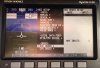
After replacement of the NAV/COM Garmin SL 30 with the Trig 96Y (which should be plug and play wit a Trig-supplied adapter) and Dynon software update, everything works fine except the course indicator. GPS is a Garmin 496.

Previously working:
selecting NAV or GPS as nav data source
using GPS data for wind, course display (magenta V) at the compass scale, TAS calculation

Now working: selecting GPS as nav data source
using GPS data for wind, TAS calculation, as course on the HSI page

Not working anymore: display the course as magenta V at the compass scale. It stays at 0° while in flight or on the ground.

I don't understand this as the very same data are transmitted and displayed at the HSI page
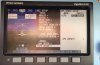
 

Attachments

  • Photo-2018-07-01-13-16-09_8637_Kopie.jpg
    Photo-2018-07-01-13-16-09_8637_Kopie.jpg
    112.8 KB · Views: 329
  • Photo-2018-07-01-13-16-40_8638_Kopie.jpg
    Photo-2018-07-01-13-16-40_8638_Kopie.jpg
    273 KB · Views: 389
  • Photo-2018-07-01-13-16-54_8639_Kopie.jpg
    Photo-2018-07-01-13-16-54_8639_Kopie.jpg
    201.4 KB · Views: 408

Dynon

Dynon Staff
Staff member
Joined
Jan 14, 2013
Messages
14,232
Location
Woodinville, WA
So I'm not sure if you're making a statement about the NAV working or not. But as far as the GPS goes, if you've changed the NMEA settings, make sure that under the advanced NMEA page, the data rate is set to "normal", not "high". Note that this is NOT the baud rate setting.
 

kluge

I love flying!
Joined
Jan 21, 2015
Messages
18
I wasn't clear, sorry:
Course information from the NAV receiver (VOR) isn't there anymore as the radio replacement doesn't have NAV capability.

My point is that the serial data connection between GPS and Dynon D180 is established. GPS data displayed by the D 180 are: calculated wind, UTC, course, distance, (don't remember about track in flight anymore).

But the course data is displayed at the HSI page only and not at the compass scale at the main screen as it was before the update and new radio installation. Instead, the magenta V for the course stays at 0° and not at 253° as it should in my example. See first photo.
 

Dynon

Dynon Staff
Staff member
Joined
Jan 14, 2013
Messages
14,232
Location
Woodinville, WA
Got it. Definitely, check the advanced NMEA setting on the Garmin. Also, you probably previously had your GPS set to output the NMEA + VHF Out at 9600 baud. Did you change that? No need to. So if you did, try changing it back.
 

kluge

I love flying!
Joined
Jan 21, 2015
Messages
18
Checked the connection: The D180 receives GPS data if output of the Garmin 496 is set to either:

Input NMEA, output NMEA, forced 4800 baud
or
Input Aviation, output NMEA and VHF, forced 9600 baud

and the D 180 is set to either Input Auto or Input NMEA and the baud rate is set to either Auto or the correct baud rate.

If the connection is established, GPS course and distance data are displayed at the HSI page and when in flight, track and wind are displayed, but the course indication at the compass scale in the main EFIS screen rests at 0° (see first photo). The track indicator (down arrowhead) works fine.
 

Dynon

Dynon Staff
Staff member
Joined
Jan 14, 2013
Messages
14,232
Location
Woodinville, WA
Did you check the Advanced NMEA menu settings? You don't mention it here. That one is key. Again, you want the data rate set to "Normal", not "Fast". On most devices you hit the menu button once you're in the NMEA setup menu.
 

kluge

I love flying!
Joined
Jan 21, 2015
Messages
18
Thanks, that was the solution. Now everything works as it should
 
Top