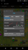
Garmin Pilot just added a new feature that I would love to see on my Dynon SkyView. It displays the best runway based on the ADS-B weather data. See attached pic for specifics. IMHO (cough), this is great feature for non-controlled airports and significant step forward in "exploiting" the new digital ADS-B data available in our systems.
I would also love to see a way of adding the key information for the destination airport on the MAP screen. For instance, assign one or two the 5 left/right side spots on the map screen to display runways for the airport, TPA, and if available winds from ADS-B.
Thanks!
Don
I would also love to see a way of adding the key information for the destination airport on the MAP screen. For instance, assign one or two the 5 left/right side spots on the map screen to display runways for the airport, TPA, and if available winds from ADS-B.
Thanks!
Don