Terrain warning, terrain profile, color coded SVX

pc

I love flying!
Joined
Feb 6, 2014
Messages
14
Is there a terrain warning in the SV system? like in the cheapest GPS devices like AERA 500?
Is there option to turn on color coding , i.e. yellow and red like the map produces but on the Syntetic Vision on the PFD so the tops of mountains are painted accordingly?
Would be nice to have terrain profile along the flight route ...
 

ckurz7000

I love flying!
Joined
Jan 22, 2014
Messages
43
Location
Austria
There is terrain warning and you can also shade it so that it shows yellow and red when you're getting too close. I am not aware of a terrain profile view, though. However, synthetic vision and the mapping feature are optional items that cost.

-- Chris.
 

pc

I love flying!
Joined
Feb 6, 2014
Messages
14
I do have both MAP and Synthetic Vision installed. The only terrain "warning" is on the MAP, no audio or Message and I don't have the yellow an red colors shown on the PFD... any hints where are those options enabled?
 

dynonsupport

Dynon Technical Support
Staff member
Joined
Mar 23, 2005
Messages
13,226
SkyView does not have any "active" warnings of terrain. There is no message that will pop up or sound that will be made.

We experimented with highlighting the Synthetic Vision red when terrain is an issue, but that leads to a lot of red on SynVis a lot of the time in some environments, even if the mountain is 30 miles away. It wasn't something we felt was the correct solution. What SynVis does is that everything that is above your current altitude is above the white line on the horizon. So anything above that line is a threat.

All SkyView systems come with "look down" terrain on the map (even if you didn't buy the map). This will highlight all terrain that is above your current altitude in red. If you have a flight plan, then you can see the places that the flight plan crosses red areas.

A horizontal view of the flight plan versus terrain is something that is on our feature wish list.
 

pc

I love flying!
Joined
Feb 6, 2014
Messages
14
Thanks on the info.
As a user of Garming G1000 in my C172 im lacking those feautures on my Dynon SW.
Audible warning should not be that unimportant or difficult to implement , as well the color coding of SV in the PFD. Looking back to G1000 I see that they show the red and yellow only on peaks in the near vicinity of the plane position, not on all the PFD, therefore avoiding "lot of red"
I think you should reconsider implementing those feautures, as this will greatly improve safety and spatial awareness in flight with Skyview.
 

Steve_N

New Member
Joined
Jan 22, 2014
Messages
25
Location
EGBJ
SkyView does not have any "active" warnings of terrain. There is no message that will pop up or sound that will be made.....

My first post here. I've just completed installation of a 10" Skyview system in our Alpi Pioneer. Very pleased with it but I confess I did not expect to have to keep our Garmin Aera connected to retain audio terrain warnings.

Is there a particular reason why Dynon has not implemented them on Skyview?

ta

Steve
 

dynonsupport

Dynon Technical Support
Staff member
Joined
Mar 23, 2005
Messages
13,226
The simple answer is that there have not been many requests for this feature. This thread notwithstanding, look around and you'll see that we haven't been asked much in the 4 years SkyView has been for sale.

We maintain a huge list of feature requests, and do our best to prioritize them. It has nearly 1,000 features on it, so we have plenty to do. This feature is on that list, but it hasn't bubbled to the top, so we haven't gotten to it yet.

I think one of the reasons that it isn't asked for is that once you fly SkyView, you will see how good it is at giving you actual knowledge about the terrain all around you and along your flight path, not just in the few seconds before you hit a mountain. Our goal has always been to warn you far in advance of an issue. In those dark nights in the Arizona desert, I'd much rather see 100 miles out and know there is nothing in my way, rather than deal with the terror of an unexpected terrain alert. I hope we can all agree that it's better to never get within 30 seconds of a crash than to only warn once you do.

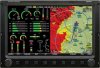
We do this with SynVis in SkyView, where everything above the line is a threat. More than that, our look-down map always highlights terrain that is an issue, no matter how far away (even in Europe when you are in the USA!). This way you can see that you are going to have an issue in 100 miles, not just when the little box in the corner pops up a few seconds before impact.

The thousands of users flying with SkyView find these methods very effective. They lead you to "just knowing" where the terrain is. I believe it is because this system is so effective that it means customers don't ask for an enhancement to this as a primary request. Look at the image below, and you can clearly see where you shouldn't go even though it is many miles away.

Now, with all that said, it is on our list, and we do expect to add it someday. But let's not act like it's easy. The last thing you want is a terrain warning going off all the time. It needs to filter itself out when it thinks you are landing. It needs to not go off when you do a loop and are on the downline at 200 MPH (only 17 seconds to impact at 5,000 AGL). It needs a way to cancel it when it is going off an annoying you. So it isn't just a few lines of code. There's a reason the TSO for TAWS is 50 pages long!

As a final note, CFIT is on a steady decline in the last 10 years, especially in well equipped homebuilts. GPS units seem to be doing their job. 15 years ago CFIT was the killer, but today it's loss of control (stall/spin and other bad piloting).
 

Attachments

  • SV-D1000_sm.jpg
    SV-D1000_sm.jpg
    14.7 KB · Views: 166

NASA515

I love flying!
Joined
Oct 23, 2012
Messages
169
As a user of Garming G1000 in my C172 im lacking those feautures on my Dynon SW.
Audible warning should not be that unimportant or difficult to implement , as well the color coding of SV in the PFD. Looking back to G1000 I see that they show the red and yellow only on peaks in the near vicinity of the plane position, not on all the PFD, therefore avoiding "lot of red"
I think you should reconsider implementing those feautures, as this will greatly improve safety and spatial awareness in flight with Skyview.


I don't think so - not at all.  With the moving map, terrain awareness, and SynVis, if you don't have "spatial awareness", you have a problem.

Flying with my good buddy with a Garmin feeding his D-180, flying circuits to runway 20 at KPWT, we get nothing but an annoying stream of TERRAIN and increasingly strident PULL-UP's every time we turn Base Leg.  That's because there's high ground to the north of the airport, but we come nowehere near it.  I also don't like it calling altitudes.

We're not shooting a Cat III approach into SEA with full Autoland.

Bob Bogash
RV-12
N737G
 

preid

Member
Joined
Jan 22, 2010
Messages
754
Location
SoCal
Our goal has always been to warn you far in advance of an issue. In those dark nights in the Arizona desert, I'd much rather see 100 miles out and know there is nothing in my way, rather than deal with the terror of an unexpected terrain alert.

Dynon is right on with this reply. I have over 200 hours behind a Synvis display and I will tell you that I have 2-3 times when I was coming from Arizona into SoCal and the display let me know that I was over 1000ft (yellow) above the path I was going and anything right of that was yellow with spots of red. My confidence was solid after the first time I went through this. I would not use audio alerts, even if I had it as a feature, too annoying and would add stress to a calm situation.
 

purlee

I love flying!
Joined
Jun 6, 2013
Messages
72
She is not called "Bitchin Betty" for nothing. While audio alerts can be lifesavers in many circumstances, if she cries "Wolf" too often you tend to tune her out or, worse still, turn her off!

As the guys at Dynon said, it is much better to see the terrain 100 miles away than to have someone shout "pull up", just before the radome hits the rock.

If you want a good illustration of this, consider Air New Zealand Flight 901, which hit Mt Erebus in the Antartic whilst navigating VFR in a whiteout which prevented them from seeing the biggest obstacle for 5000 miles in any direction.

The mountain, over 14,000 feet high, rises so steeply that the GPWS only sounded 5 seconds before impact. Had they had a system such as Skyview provides, they would have been aware of where they were and that they were heading into trouble, at least 100 miles out from impact
 

mmarien

Murray M.
Joined
Dec 26, 2009
Messages
1,206
Location
Saskatoon SK CAN
I like the 500' warning/advise that my GPS495 gives on approach to any runway. However, when I fly the mountains I turn off the audio terrain warnings as they are annoying. Neat to see the all the little X's where it predicts CFIT will happen.

On the other hand the color coded terrain on the Skyview map does make it easy to navigate up a valley or circumnavigate a mountain. No audio required.
 

paul330

Member
Joined
Mar 10, 2007
Messages
107
I sincerely hope you are not flying below a safe altitude in poor weather using your un-certified GPS to "navigate up a valley"  :eek:
 

pc

I love flying!
Joined
Feb 6, 2014
Messages
14
I found this picture searching google. Has terrain color coded like this been standard before? or we don't have mountains high like this :)
 

Attachments

  • image_026.jpg
    image_026.jpg
    69 KB · Views: 168

mmarien

Murray M.
Joined
Dec 26, 2009
Messages
1,206
Location
Saskatoon SK CAN
I sincerely hope you are not flying below a safe altitude in poor weather using your un-certified GPS to "navigate up a valley"
I didn't say anything about below safe altitudes or poor weather. But I'm pretty sure I can see which valleys I can navigate at a glance. Also notice the green valleys and brown hilltops.

Valleys.jpg
 
Top