You are using an out of date browser. It may not display this or other websites correctly.
You should upgrade or use an alternative browser.
You should upgrade or use an alternative browser.
Airspace display & SYNVISION
- Thread starter woneill
- Start date
- Joined
- Mar 23, 2005
- Messages
- 13,226
No, that is an image that a user photoshopped to demonstrate a feature request he was making. We do not show airspace on Synthetic Vision.
Jamie
New Member
You must be talking about this.

Yes, it would be a great feature for SV. I hope Dynon does include it at same stage.
Yes, it would be a great feature for SV. I hope Dynon does include it at same stage.
- Joined
- Mar 23, 2005
- Messages
- 13,226
Let me just say that we have considered this, even before we started designing SkyView. The issue is that it quickly devolves into useless clutter when you have multiple airspaces, and even single airspaces don't look anything like the above. So while it would be awesome if we could do something smart here someday, it isn't as simple as just showing airspaces because as you'll see below, this becomes useless quickly.
There's something funny about the photoshopped image above that makes it look great, but is unfortunately not real. When was the last time you saw an airspace that was taller than it is wide? Think about it- a normal class D airspace is 8 NM in diameter, but that's 48,000 ft. So if the airspace was taller than it was wide, it would go above at least 48K feet above the ground.
The red cylinder above doesn't go above the horizon line, so by definition it's lower than your current altitude, which is 2900 ft. Call the airspace 2500 ft tall, which is reasonable. However, that airspace is taller than it is wide, so it's less than 2500 ft wide- less than 1/2 mile. No real airspaces are like that.
Given real widths of airspaces, you run into the issue that you are just flying directly at a "wall" of airspace anytime you care about it. If you discount the height issue, assume the blue airspace above is a normal class D and is 8NM wide. Our field of view on SynVis is about 30 degrees when you are full screen PFD. The airspace is about 1/4 of that in the image, which is about 8 degrees.
In order for something that is 8 miles wide to be 8 degrees wide, you need to be 57 miles away from it! Not sure most people care about an airspace when they are 57 miles away.
Google earth actually allows you to play with this. You can go here and download 3D airspaces:
http://www.lloydbailey.net/airspace.html
Here's a few images to show what airspaces really look like when they're scaled like real airspaces:
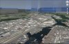
1) KTUS, 35 miles away from the airport, only KTUS airspace, 3000' AGL
2) KTUS with all other airspaces turned on (not Class E or A), 3000' AGL. Note the now looming airspace above is actually about 50 miles behind KTUS.
3) Approach to KBFI from 2 miles away from runway
There's something funny about the photoshopped image above that makes it look great, but is unfortunately not real. When was the last time you saw an airspace that was taller than it is wide? Think about it- a normal class D airspace is 8 NM in diameter, but that's 48,000 ft. So if the airspace was taller than it was wide, it would go above at least 48K feet above the ground.
The red cylinder above doesn't go above the horizon line, so by definition it's lower than your current altitude, which is 2900 ft. Call the airspace 2500 ft tall, which is reasonable. However, that airspace is taller than it is wide, so it's less than 2500 ft wide- less than 1/2 mile. No real airspaces are like that.
Given real widths of airspaces, you run into the issue that you are just flying directly at a "wall" of airspace anytime you care about it. If you discount the height issue, assume the blue airspace above is a normal class D and is 8NM wide. Our field of view on SynVis is about 30 degrees when you are full screen PFD. The airspace is about 1/4 of that in the image, which is about 8 degrees.
In order for something that is 8 miles wide to be 8 degrees wide, you need to be 57 miles away from it! Not sure most people care about an airspace when they are 57 miles away.
Google earth actually allows you to play with this. You can go here and download 3D airspaces:
http://www.lloydbailey.net/airspace.html
Here's a few images to show what airspaces really look like when they're scaled like real airspaces:
1) KTUS, 35 miles away from the airport, only KTUS airspace, 3000' AGL
2) KTUS with all other airspaces turned on (not Class E or A), 3000' AGL. Note the now looming airspace above is actually about 50 miles behind KTUS.
3) Approach to KBFI from 2 miles away from runway
Attachments


- Joined
- Mar 23, 2005
- Messages
- 13,226
mmarien
Murray M.
In defense of my mockup I used the ratios from the map on the left to scale the width of the airspace. I used the altitude ribbon to show the height. I'm at 2900' so the top (5000') of the Class D zone airspace should be above the horizon line and extend to the ground below. But you are right, the scale is out to lunch.
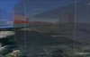
Thanks for the tip about google and the airspaces. It's a great app I didn't know about. Despite the obvious scaling errors in the mockup I did I still like the idea of 3D air spaces in synthetic vision. In Google Earth, from a distance they show a clear picture of the air spaces ahead. From close up they get a bit confusing. In the one below near CYXE, there are restricted air spaces to the right, a Class E disk (2900-3900') and a smaller Class D disk around the airport. Makes it easy to navigate into CYXE. I can either contact approach or duck down below the Class E and call tower later.
Perhaps being able to toggle classes on and off would clear up some of the clutter and confusion. Color would also help. The restricted air spaces could be an ominous red. It might also be useful to see the Class D through the Class E as it extends to 5000' but higher classes would be opaque to lesser classes behind them.
Given what you have already done with synthetic vision Google Earth is probably a poor indication of what could be done.")

Thanks for the tip about google and the airspaces. It's a great app I didn't know about. Despite the obvious scaling errors in the mockup I did I still like the idea of 3D air spaces in synthetic vision. In Google Earth, from a distance they show a clear picture of the air spaces ahead. From close up they get a bit confusing. In the one below near CYXE, there are restricted air spaces to the right, a Class E disk (2900-3900') and a smaller Class D disk around the airport. Makes it easy to navigate into CYXE. I can either contact approach or duck down below the Class E and call tower later.
Perhaps being able to toggle classes on and off would clear up some of the clutter and confusion. Color would also help. The restricted air spaces could be an ominous red. It might also be useful to see the Class D through the Class E as it extends to 5000' but higher classes would be opaque to lesser classes behind them.
Given what you have already done with synthetic vision Google Earth is probably a poor indication of what could be done.
I agree with Dynon. I dont see much utility out of it and see it just cluttering up the synthetic vision display.
I like the way WingX relays airspace information to you by simply telling it to based on your current position like so:
Class B 4000 - 10000
Class C 3000 - 4000
Class D SFC - 2500
IE, it would be great if i could just simply place the pointer at a spot on the map, and the airspace altitudes would be displayed like above.
For San Francisco, it is difficult for me to decipher what the altitudes are for my rings of airspace, because the text is overlapped on top of other text and it becomes very obfuscated. I look at the Skyview map and end up zooming in and out several times, just to double check and re-double-check to make sure i am not busting airspace. More than half the time, I give up with the Skyview map and go by memory or just refer to the Ipad (when i have it with me) because it's easier.
I can't imagine how bad it must be for LAX.
DennisW
New Member
When I was working on synthetic vision at NASA a few years ago, we decided the same thing that Dynon has decided about airspace depiction, however, Special Use Airspace (SUA) depiction would be wonderful. Especially for TFRs and active SUA, but this can only happen once you have a datalink capability like XM or the UAT connected and those indications are datalinked as they become active. We did some research with this capability as well and it is quite helpful.
mmarien
Murray M.
In the prairies there is not a lot of clutter on the synthetic vision screen unless you're low enough to make obstacles appear. Also if you are close enough to see a runway in synthetic vision then you would be in the middle of the highest class airspace so it would block any other airspace clutter beyond it using the hierarchy opaque rules mentioned above. Like obstacles or traffic, airspaces would only display when in range.I dont see much utility out of it and see it just cluttering up the synthetic vision display.
I don't see a lot of reason to have roads and such in synthetic vision. However, terrain, obstacles, traffic and airspaces are 3D things you might want to see so they can be dealt with. I still think done right 3D airspaces would be useful. It could have the option of turning it off.
What might be useful in addition to 3D airspace would be a text box showing what class of airspace you are currently in, and like other GPS devices, a warning (reminder) about imminent airspaces. It would popup much like the traffic or obstacle warning.