Hi Dynon,
Some time ago, Dynon had a neat program that allowed users to place waypoints on Google Earth and then capture them onto a USB stick and upload them into the Dynon Skyview unit.
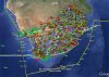
Recently, our South Africa ATNS has released a free google kmz file that has all the South Africa airspace shown.
There are many Dynon skyview units flying in South African aircraft.....Please would Dynon consider converting this data file into a format that we can upload onto our Dynon skyview units? It would be a great help to many of us.
Regards
Steve
Some time ago, Dynon had a neat program that allowed users to place waypoints on Google Earth and then capture them onto a USB stick and upload them into the Dynon Skyview unit.
Recently, our South Africa ATNS has released a free google kmz file that has all the South Africa airspace shown.
There are many Dynon skyview units flying in South African aircraft.....Please would Dynon consider converting this data file into a format that we can upload onto our Dynon skyview units? It would be a great help to many of us.
Regards
Steve