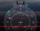
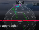
I just saw a you tube video on best practices or procedural tips, for IFR Instrument Approaches, using the Garmin G1000. It mentioned, and demonstrated, how the display of the CDI on the HSI would behave when transitioning from the last leg prior to intercepting the localizer & Glide Slope signal. As you approach, buit before you are within range of the glide slope signal, the HSI displays two CDIs, one, in Magenta, which is sourced from the RNAV (GPS) data, and another, in a dashed white color, that represents the localizer signal. When the localizer signal has been identified and validated (it hears the morse code ID), the RNAM CDI goes away, and the LOC CDI goes solid and green, indicating that the CDI is now sourced from the localizer.
Does the Skyview HSI/CDI do this?
If it does not, is this feature possible/feasible with current Skyview hardware?
and if so, is it planned? and if it is not, might I suggest that it be added to the list of future upgrades?
Does the Skyview HSI/CDI do this?
If it does not, is this feature possible/feasible with current Skyview hardware?
and if so, is it planned? and if it is not, might I suggest that it be added to the list of future upgrades?