Vincentsei
I love flying!
- Joined
- Mar 29, 2014
- Messages
- 12
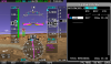
First off thanks for the latests version of software it fixed most of the integration issues with us orphans who love our CNX80s/GNS480s. This restored the serial waypoints coming from the unit as well as problems with the ARINC data. but there seems to be one small problem with the ARINC navigation data being displayed on the HSI. On the map page I can see all my way points and distances that the CNX-80 is passing the Dynon. The flight plan plots on the skyview map just fine, but on the HSI the name of the waypoint is just _ _ _ _ _. Since the name is being listed on the flight plan page of the Skyview I think the data is coming across just fine and that I have something not right on the HSI setup or there is small software bug that the HSI doesn't think it has the name of the waypoint. The distances on the HSI are correct though. I have attached a screenshot of me flying to ABQ which is listed on the flight plan page to the right but the HSI is showing the dashes with the CNX-80 as the HSI source. Anything I can try to resolve this or is it just a bug right now? Thanks
Vince
Vince