Hi
We have imported two new aircraft from Europe with dual 10" Dynon Skyviews and a couple of questions. Both have Rotax 912 is engines with the 221 EMS.
1. When stationery the engine instruments have crosses which come off on start up. I'm guessing thats because the sensors are not used and the data is coming from the Rotax EMS is that correct or do we have a set up issue?
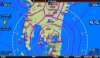
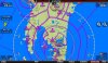
2. For the mapping I believe we have the Dynon mapping sv-map-270 certificates. When they start up we get base layer and terrain and no warnings and I'm assuming if we did not have the certificate there would be some indication it was under 30 hour trial?
3. To add aeronautical data, I understand we have two choices, Jeppesen or Pocket FMS. Is there any location we can see screen shots of NZ actual mapping images to see resolution and what data is displayed, for example do either include aerodrome charts?
4. I understand we need to supply the serial number of either the master screen (presumably lefthand side in each cockpit) or alternatively both serial numbers. Is the serial number 5 digit numberic displayed under display set up license?
5. The databases installed are listed as REG - 13 - South Pacific Hi Res
AVDATA 10/17/13-12/11/13 FAA Worldwide terrain low res
OBDTAT 10/17/13-12/11/13 FAA
Worldwide terrain very low res
Base map created on 05/08/13 Europe
Are these the most appropriate?
6. Final question I assume we will not have the latest firmware installed as the aircraft were shipped from Europe in March so I should first update the firmware with version 10.1, is there a way I can confirm the version installed?
Thanks
John
We have imported two new aircraft from Europe with dual 10" Dynon Skyviews and a couple of questions. Both have Rotax 912 is engines with the 221 EMS.
1. When stationery the engine instruments have crosses which come off on start up. I'm guessing thats because the sensors are not used and the data is coming from the Rotax EMS is that correct or do we have a set up issue?
2. For the mapping I believe we have the Dynon mapping sv-map-270 certificates. When they start up we get base layer and terrain and no warnings and I'm assuming if we did not have the certificate there would be some indication it was under 30 hour trial?
3. To add aeronautical data, I understand we have two choices, Jeppesen or Pocket FMS. Is there any location we can see screen shots of NZ actual mapping images to see resolution and what data is displayed, for example do either include aerodrome charts?
4. I understand we need to supply the serial number of either the master screen (presumably lefthand side in each cockpit) or alternatively both serial numbers. Is the serial number 5 digit numberic displayed under display set up license?
5. The databases installed are listed as REG - 13 - South Pacific Hi Res
AVDATA 10/17/13-12/11/13 FAA Worldwide terrain low res
OBDTAT 10/17/13-12/11/13 FAA
Worldwide terrain very low res
Base map created on 05/08/13 Europe
Are these the most appropriate?
6. Final question I assume we will not have the latest firmware installed as the aircraft were shipped from Europe in March so I should first update the firmware with version 10.1, is there a way I can confirm the version installed?
Thanks
John
")