Eastern Canada hi-resolution GPS

castleb

Taildragger Pilot
Joined
Sep 8, 2013
Messages
5
Location
Fredericton, NB CANADA
I fly an RV-4 out of Weyman Airpark CCG3 in New Brunswick, Canada. Have had the Dynon Skyview D700 for over a year (and love it...), but cannot seem to get high resolution base map or regional cultural info to display. I have downloaded and installed base_map_north-america_6.dup and reg-02-north-america.dup along with SkyView-6.2.0-dynon_update.dup. I tried Canada-Alaska versions but also low resolution.

Any suggestions?
 

dynonsupport

Dynon Technical Support
Staff member
Joined
Mar 23, 2005
Messages
13,226
What makes you think you don't have the high resolution data working? It could be things other than the database so we need to know what you are seeing or not seeing to diagnose the issue.
 

castleb

Taildragger Pilot
Joined
Sep 8, 2013
Messages
5
Location
Fredericton, NB CANADA
OK. The screen shows no roads, railways, towns or small rivers at any zoom. The major river - Saint John River in New Brunswick - is large but disappears as no warterway part way through its meanderings. At higher zooms, I get pixelation that makes me think the background is low resolution rather than high resolution. My handheld Garmin Aera 500 has much better base map terrain imagery.
 

mmarien

Murray M.
Joined
Dec 26, 2009
Messages
1,206
Location
Saskatoon SK CAN
What does your Installed Databases show?

InstalledDatabases.jpg
 

dynonsupport

Dynon Technical Support
Staff member
Joined
Mar 23, 2005
Messages
13,226
With the following databases installed, this is what CCG3 looks like for us:
 

Attachments

  • screenshot-20130910-010958-068.png
    screenshot-20130910-010958-068.png
    84.8 KB · Views: 116
  • screenshot-20130910-010805-901.png
    screenshot-20130910-010805-901.png
    763.2 KB · Views: 107
  • screenshot-20130910-010923-113.png
    screenshot-20130910-010923-113.png
    595.3 KB · Views: 98

mmarien

Murray M.
Joined
Dec 26, 2009
Messages
1,206
Location
Saskatoon SK CAN
When the landscape doesn't rise above a few hundred feet I don't think the synthetic vision or terrain is going to be very dramatic. It gets better with bigger rocks.

Robson1.jpg


And I think that is all you get for cultural data. If you're comparing it to Garmin then they definitely have more resources and a bit more experience with roads. On that topic I happen to notice the maps that come with Savvy Analysis are open source. They seems to be much more detailed then the cultural data that Skyview is using. Has Dynon considered that source?

https://www.savvyanalysis.com/flight_map/385650/62b8f7e2-3b0f-4769-a275-ddef8af01163
 

castleb

Taildragger Pilot
Joined
Sep 8, 2013
Messages
5
Location
Fredericton, NB CANADA
I checked my installed databases and I have pretty much what you have. The base map was Canada-Alaska and I changed it to North America. I reloaded the reg-02-north-america.dup but it didn't seem to make a difference. I have pretty much what you show on your screenshots.

I guess that's the best it can do. I was expecting towns to show up, but I guess not here...

Thanks for the shots and the advice. Seems to be fine now. Perhaps I was expecting too much...
 

dynonsupport

Dynon Technical Support
Staff member
Joined
Mar 23, 2005
Messages
13,226
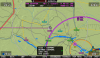
We do have a lot of towns, but you may not see them for two reasons:

1) We limit based on "size" which is population. Go into your MAP ITEMS list and you will see small towns are turned off above 5NM or so. You can turn this up. For the USA, if we have this turned up, places like Seattle, LA, NYC, etc, are just floods of "towns".

2) City names are lowest in priority in drawing, so a lot of things trump them. For instance, the VCPMB VRP is right on top of the location for Fredericton, so we don't draw Fredericton at a lot of zoom levels.


As for using other road data, the issue always is road classification. We don't show every road, since that would just be a black mess (and would take gigabytes of storage). So we show primary and secondary roads, and we use the data right from the Canadian government. The issue is how they classify roads, and what they consider primary and secondary. They don't even consider them the same in every province.

We have considered Open Street Maps. While Savvyanalysis is an always-connected app that can just draw their data on top of an OSM image, with almost zero work, we can't quite do that. Dealing with their raw data is extremely problematic, and they have huge gaps in lots of parts of the world. They get better every day and we do keep an eye on them. Their raw data is only 370GB ;)
 

Attachments

  • screenshot-20130917-223128-893.png
    screenshot-20130917-223128-893.png
    725.7 KB · Views: 110
Top