External GPS data

AlanR

Member
Joined
Jan 25, 2007
Messages
187
Location
UK
Sorry but some info needed please that I am sure you have answered umpteen times. I am still in the pre purchase decision phase..
Trying to weigh up the Pro's and Con's of Internal v External GPS

What info from an external GPS (say 695) will be displayed on the Map page.?
All FPL route data?
Magenta FPL route line on the Map?
Route feed to the HSI?

The advantage of having an external portable GPS for me means I can programme my FPL route etc at home before going to the airfield.

Also would having an external GPS cause any autopilot issues that an internal GPS wouldn't?

Thanks in anticipation...
 

mmarien

Murray M.
Joined
Dec 26, 2009
Messages
1,206
Location
Saskatoon SK CAN
What info from an external GPS (say 695) will be displayed on the Map page.?
None
All FPL route data?
?NO
Magenta FPL route line on the Map?
NO
Route feed to the HSI?
YES
Also would having an external GPS cause any autopilot issues that an internal GPS wouldn't?
NO. SV AP will follow either device flight plan. The SV flight plan will do the turns better than an external device flight plan.

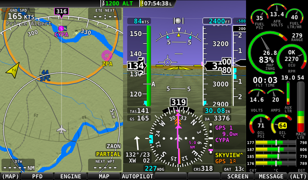
SV will follow a flight plan from an external GPS but it won't show it on the SV Map page. It will show it on the HSI. Here is an example. SV AP is following the Skyview route. There are three directions shown on the HSI. The magenta Skyview route which is the current route. It is also shown in Yellow. The other route is from the second navigation device GPS 1 and is shown in orange.


xGPS.png
 

DBRV10

Active Member
Joined
Jun 15, 2008
Messages
926
Location
Brisbane, Qld. Australia
I am not sure I would agree with all of that.

The SV will indeed follow an external GPS very nicely indeed. The GPSS output from the GTN series GPS is very accurately flown. You should use it to fly a GPS RNAV approach, it rounds the corners beautifully.

As for displaying the external flight plan. YES SIR! We rarely if ever put a flight plan into the SV. We load all flights and even DTO's into the Garmin GTN750 and it instantly "Crossfills" into the SV. Even when we load an approach the RNAV waypoints all Crossfill exactly as per the GTN plan.

Take a look here, this is a photo that was taken at FL130 dodging some large CU's and it was very bright, but if you see the plan in the GTN, it is replicated on the SV on the RHS. Might need to download and zoom up to it to see it.

http://i849.photobucket.com/albums/ab58/jaba430/SVXFILL_zps4a4928c0.jpg

SVXFILL_zps4a4928c0.jpg


If I have misunderstood the above posts….my apologies in advance. :)
 

AlanR

Member
Joined
Jan 25, 2007
Messages
187
Location
UK
Thanks guys for the input...
However you both seem to have differing opinions on the'Crossfill' of data from an external GPS?

You seem to be saying that data crossfills across ok on the GTN but doesn't on a 695?

I will in all probablility be using a garmin 695 external gps so if you could clarify it would be appreciated.
Got it that it will feed the data to the HSI ok but I need someone to confirm again please what data regarding the FPL route data (magenta line etc) on the Map will be shown and crossfed across?
 

mmarien

Murray M.
Joined
Dec 26, 2009
Messages
1,206
Location
Saskatoon SK CAN
I only found one screenshot with SV following the GPS495 (GPS 1) route and it doesn't show on the SV MAP page. It's dated June.2013. Don't know if the newer versions of SV changed that. Looks like the Garmin GTN series do cross fill to the SV Map. Nice system David :cool:

yGPS.png
 

mmarien

Murray M.
Joined
Dec 26, 2009
Messages
1,206
Location
Saskatoon SK CAN
Just some thoughts for your decision process.

I have the GPS495. Had it before the SV and incorporated it into the panel when I upgraded to SV. It worked well as a navigation device even after I added AP to SV when it became available. I used it for flight planning as you suggest. A couple of problems were detaching it from the airgizmo mount to take it home and the limited flight planning or just difficult user interface of the GPS495. Also the screen is very tiny.

I migrated to using a computer based program for flight planning and uploaded it to SV (and GPS495) via GPX format on the USB thumb drive. When Foreflight offered Canadian VNC maps I switched to an iPAD and Foreflight which I have mounted on my panel. The only problem was transferring the flight plan to SV. There is no method at the moment.

That doesn't seem to be a problem. I use the DTO on SV to get me to the next waypoint and that is the limit of my flight planning on SV. My route is way too dynamic beyond the first waypoint to bother entering the next waypoint. Weather, mountains, let's follow the river, etc. all keep the trip fun. I just try to keep the purple line on the map. If it goes off I just redo the DTO. No problem. Good flight planning does tend to go astray once on the way.

Your experience may differ. ;)

iPad.jpg
 

dynonsupport

Dynon Technical Support
Staff member
Joined
Mar 23, 2005
Messages
13,226
To be clear about what SkyView can and can't do:

With a certified, panel mount GPS, we can share flight plans, show the plan on our map, etc. However, we cannot do this with a non-certified GPS that outputs NMEA over RS-232. We generally assume if you have something like a 696 in the panel it's because you prefer to use that as your map.

You still need our map license to do so. We won't show this data on our map page if we don't have a map license loaded.

With NMEA (which a 696 has) we can show the course and CDI on the HSI and the AP can follow it 100%. This works on every SkyView, map license or not.

If your primary goal is to do flight planning at home, SkyView can load flight plans off a USB memory stick in .GPX format, so you might have a flight planning tool on a PC that works for you. I'd also ask you to hold off on your decision until our next firmware release as it might also help your decision if planning at home is a primary goal.
 

AlanR

Member
Joined
Jan 25, 2007
Messages
187
Location
UK
mmarien,,Thanks for the great help..appreciated!

Dynon..This also is very helpful stuff. are you saying that if I have a map licence data from say a 695/6 it could be crossfed but not if I did not have a license?

Flight planning at home is very useful to me...saves time etc at the airfield prior to the flight.
I don't have to make a decision for a couple of months, so thanks for the information that it is beneficial for me to hold off for a while....much appreciated. I will wait and watch with interest :)
 

dynonsupport

Dynon Technical Support
Staff member
Joined
Mar 23, 2005
Messages
13,226
No matter what, we cannot crossfeed the entire flight plan from a 696 and display it on our map. We can, however, show it's course and CDI information on our HSI and fly the and AP from it, but it will never show up on the map page.
 

johnsteichen

New Member
Joined
Sep 18, 2010
Messages
227
I have found no serious need for the take home flight planner (foreflight) to automatically transfer the information to either the GTN 750 or to Skyview. Flight plans get increasingly simple with direct IFR approvals. The time it takes to enter the flight plan into skyview or the driving Garmin is of no consequence. If anything, the re entry allows you to confirm the flight plan you have created. Your mind needs to engage somewhere along this process. ;)
 

DBRV10

Active Member
Joined
Jun 15, 2008
Messages
926
Location
Brisbane, Qld. Australia
If anything, the re entry allows you to confirm the flight plan you have created. Your mind needs to engage somewhere along this process.

John, that is an excellent post.


Not sure about your IFR requirements, but here the rules require two pilots to enter and cross check entered data. Of course when doing single pilot IFR, you do not have a second pilot, so it is the pilots responsibility to not only enter the waypoints but then to check the entered data by the GPS DIST and TRK compared to the pre-prepared flight plan. Hence an integrity check.

After that any cross filling from a GTN to a MFD is OK because it is validated already.
 

AlanR

Member
Joined
Jan 25, 2007
Messages
187
Location
UK
Hi Dynon,

Previously in this thread you intimated that in the next fimware release there maybe something in the way of a home flight planning tool or something to assist in this process?
Difficult I know but do you have any idea when, or some sort of indication of the time frame please? I see you have a new release out today but doesn't seem to cover this.

Regards,
Alan
 
Top