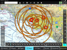
Multiple over-lapping Inactive TFRs obscures the Map view

Bsquared

New Member
Joined
May 29, 2022
Messages
5
This is probably a rare occurrence but annoying none the less. The Americas Economic Summit will be in Los Angeles the next few days so there are multiple over-lapping inactive (pending) VIP TFRs covering the entire LA area. My home airport (WHP) is within the boundaries of three of these pending TFRs. When I departed on a local VFR flight this evening my HDX map page went 100% non transparent yellow. All terrain features and airspace boundaries were 100% obscured. The only thing I could see on the map was traffic (good because the airspace was busy). I am guessing this is because with one TFR the yellow is semi transparent but when you stack up three it becomes totally saturated and hides everything. Could this be addressed in a future software upgrade?

Below is a screenshot from my iPad software showing the multiple TFRs
 

Attachments

  • Screenshot 2022-06-08 at 9.29.45 AM (002).png
    Screenshot 2022-06-08 at 9.29.45 AM (002).png
    690.3 KB · Views: 146
Last edited:

swatson999

Well-Known Member
Joined
Oct 6, 2010
Messages
1,537
I've seen this a time or two. One of the issues that may be hard to address is that at least one of these is a *single* TFR with no less that *six* different areas, effective at different times (that is, the overall TFR is effective today through Friday, but the pairs of 10 and 30 nm rings are each effective at different times throughout that period). I do agree that the best solution is probably just to "or" these colors together when there are multiple TFRs, rather than increasing the color saturation/opacity.
 

RVDan

I love flying!
Joined
Aug 8, 2012
Messages
281
Location
Frederick, MD
Happens all the time around the Washington DC/ east coast area. I would suggest reducing the opacity of TFR’s to the minimum useful. That way when they overlap the map is still usable.
 

Bsquared

New Member
Joined
May 29, 2022
Messages
5
Happens all the time around the Washington DC/ east coast area. I would suggest reducing the opacity of TFR’s to the minimum useful. That way when they overlap the map is still usable.
Thanks
I reduced it to 40% opacity, which is ok with 2 overlapping. Three is still a problem but such a rare occurrence I can live with it.
 

HFMan

Member
Joined
Aug 28, 2019
Messages
80
For those wondering:

The level of opaqueness for TFRs can be adjusted under MAP SETUP > MAP ITEMS > TFR OPACITY. (press-and-hold Buttons 7+8, then selecting MAP SETUP > MAP ITEMS > TFR OPACITY).
 

Scottmaitland

New Member
Joined
Nov 10, 2022
Messages
2
For those wondering:

The level of opaqueness for TFRs can be adjusted under MAP SETUP > MAP ITEMS > TFR OPACITY. (press-and-hold Buttons 7+8, then selecting MAP SETUP > MAP ITEMS > TFR OPACITY).
Thank you....five years after your post.....for this incredibly helpful post since North Carolina is a battleground state in 2024 and the &*%$^^ TFR's are happening all the time!
 

Jim8JD

I love flying!
Joined
Aug 4, 2018
Messages
17
Location
Tucson, AZ
Happens all the time around the Washington DC/ east coast area. I would suggest reducing the opacity of TFR’s to the minimum useful. That way when they overlap the map is still usable.
I ran into this problem flying around the north side of the DC SFRA the first week of June. My SV touch was showing a 60 nm flight restriction from surface to 18000', which included an additional 30 nm's outside the SFRA. My flight path was through the outer 30nm's. I had taken and passed the required online course before flying within 60 nm's, as is required. The DC TFR's didn't show-up until I was south of Pittsburg and I didn't know about the TFR opacity setting. The opacity setting, default set to 100%, made it next to impossible for me to see the airspace info around BWI. After diverting to N68 and making calls I learned the TFR was only speed restrictions inside the SFRA of less than 180 kts and 230 kts in the outer 30nm's, which I found to be ridiculous that it showed up like a restricted flight area on my map. After I got home I did some research and found out about the TFR opacity setting in the Dynon forums, which was a little late to help me out during my trip. The DC TFR's didn't show up until I was within 80 nm's from there, so I had no way of knowing that would happen earlier in the flight, so it was very alarming. I think the default TFR opacity setting should not be 100% ... maybe 40. Mine is now set to 10%. It will still show a red circle around TFR's, but it won't blank out the airspace info within the TFR.
 
Top