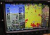
First of all: the pocketFMS aviation-data is a great feature. Just a little thing must be solved: When looking to the pocketFMS created runway displayed in the PFD, the designation is that one of the opposite direction. Looking to the attached picture approaching RWY 07, but 25 is indicated.
According pocketFMS, its a software-bug of Dynon, not pocket-FMS.
Does update 3.2 solve this problem?
According pocketFMS, its a software-bug of Dynon, not pocket-FMS.
Does update 3.2 solve this problem?