SkyView 4.0 Now Available!

Status
Not open for further replies.

dynonsupport

Dynon Technical Support
Staff member
Joined
Mar 23, 2005
Messages
13,226
To all our SkyView customers, SkyView software version 4.0 is now available.

4.0 Adds:

Basemap: Roads, rivers, cities, railroads, etc. This is a free database, available worldwide in high resolution.

Greatly enhanced mapping visuals: Graphics that match the style and color of sectional type charts. European airspace details have been added to reflect all airspace categories.
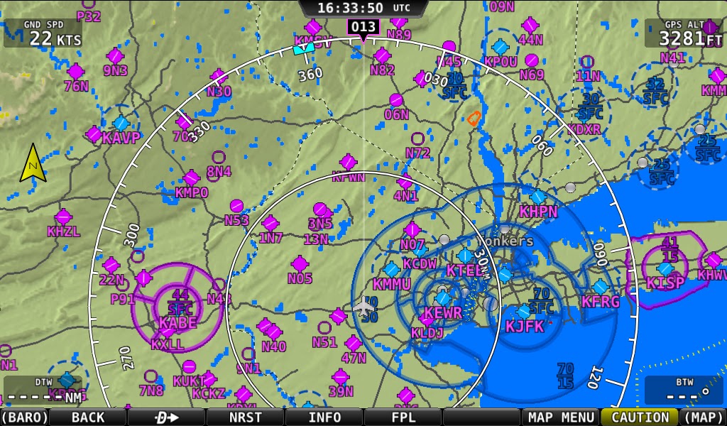
screenshot-20120821-163350-943.bmp


AHRS Cross-Checking: Multiple AHRS units are now constantly cross-checked in the background and will alert the user if they do not agree. The user is then presented with a simple display of both attitude solutions so they can choose the correct one.

Enhanced Network redundancy: The system now utilizes a fully redundant power and data network between the SkyView screens and modules. This prevents almost all single wire failures from causing a loss of data.

Visit the download link here.
 

dynonsupport

Dynon Technical Support
Staff member
Joined
Mar 23, 2005
Messages
13,226
Sectional of the above area here
 

Attachments

  • JFK.bmp
    1.6 MB · Views: 231

Jamie

New Member
Joined
Oct 4, 2009
Messages
105
Location
Brisbane, Australia
Hello Dynon,
Can you please tell me if this is the correct way to go for NON usa users.

Get the 4.0 software ( not the packaged US )
Get the Detailed Worldwide Regionalized Base Map Databases released 8/21/2012

No need to update the 3 files, Terrain - Worldwide by Region ?
 

preid

Member
Joined
Jan 22, 2010
Messages
754
Location
SoCal
"Greatly enhanced mapping visuals: Graphics that match the style and color of sectional type charts"
Looks excellent!
The picture is excellent for NY area! Are the colors reflected for the Military airspace as well?. Has that changed to reflect the blue for Restricted/Prohibited? or is it orange? Warning= Yellow?
thx!
 

Dw1oakes

New Member
Joined
Nov 1, 2010
Messages
78
Dynon Support: Can I download the 4.0 version using firefox on my MAC?
thanks
Dave
 

dynonsupport

Dynon Technical Support
Staff member
Joined
Mar 23, 2005
Messages
13,226
Hello Dynon,
Can you please tell me if this is the correct way to go for NON usa users.

Get the 4.0 software ( not the packaged US )
Get the Detailed Worldwide Regionalized Base Map Databases released 8/21/2012

No need to update the 3 files, Terrain - Worldwide by Region ?

Correct, you just need to download the 4.0 file and the correct basemap for your area. No other files are needed.
 

preid

Member
Joined
Jan 22, 2010
Messages
754
Location
SoCal
MOA's are magenta with inward ticks, just like a sectional.
Thank you but has that changed to reflect the blue for Restricted/Prohibited? or is it orange? Warning= Yellow?
 

dynonsupport

Dynon Technical Support
Staff member
Joined
Mar 23, 2005
Messages
13,226
We decided to go with orange for restricted/prohibited, and yellow for warning/caution. This sticks out a lot more on a map than just another blue line which can look a lot like a class B or D airspace.
 

RV711AC

Member
Joined
Oct 2, 2011
Messages
65
If you look below 3N5 on the Skyview map you will see 13N, if you look at 3N5 on the sectional you see 12N which I believe is correct for Aeroflex Andover. Is this an error in the FAA data or some translation artifact?
 

preid

Member
Joined
Jan 22, 2010
Messages
754
Location
SoCal
If you look below 3N5 on the Skyview map you will see 13N, if you look at 3N5 on the sectional you see 12N which I believe is correct for Aeroflex Andover. Is this an error in the FAA data or some translation artifact?

Skyview is correct, look at the scren there are three airports (3n5/12n) and 13n is slightly south. I believe 13N is missing from the sectional! It is about 4 miles south of 12N in reality.
 

preid

Member
Joined
Jan 22, 2010
Messages
754
Location
SoCal
We decided to go with orange for restricted/prohibited, and yellow for warning/caution. This sticks out a lot more on a map than just another blue line which can look a lot like a class B or D airspace.

I agree!
thx
 

RV711AC

Member
Joined
Oct 2, 2011
Messages
65
Am I missing something? All I find is F/W 3.3.2 and map data 4.0. I was looking for release notes and didn't see those for 4.0 either.
 

dynonsupport

Dynon Technical Support
Staff member
Joined
Mar 23, 2005
Messages
13,226
When they do sectionals, they do leave off airports if the clutter the sectional. They're even allowed to offset the locations of things a bit to make them easier to read! So yes, 13N is missing because it's the smallest of the 3 airports. 12N is missing on ours (the text at least) because it's clobbered by the 3N5 text. Of course, if you zoom in, it comes back. Remember, the above map is showing you a map that is about 100 miles wide, so there's a lot of data there.
 

Bruno

Member
Joined
Sep 6, 2008
Messages
220
Hi Support

           What about the enhance autopilot features everybody was waiting for, like G/S Capture, VNAV etc..

Are they in there somewhere??

Also, as a Canadian using PocketFMS, which file should I download since my Skyview is already set up to my liking?


Thanks

Bruno
:-?
 

dynonsupport

Dynon Technical Support
Staff member
Joined
Mar 23, 2005
Messages
13,226
There are some small autopilot bug fixes in the 4.0 software, but no major feature additions. Those are coming for sure but we do not have a specific date.
 

swatson999

Well-Known Member
Joined
Oct 6, 2010
Messages
1,660
Where on your future capabilities/features list are georeferenced approach plates and IFR en route charts? What about HITS?
 

barbeau

New Member
Joined
Jun 15, 2010
Messages
47
Hi
Good news....
I fly over europe and use Jeppesen data for the time being.
May I update to V 4.0 unless full fonctionality anyway?
I plan to move to Pocket FMS DATA, once again, may I update my Skyview before getting new data?
Are FMS data better in Line with new fonctionnalities?
Bernard
 
Status
Not open for further replies.
Top