1st: Graphic's error in the airport INFO DIALOG (gray vertical bar).
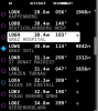
2nd: Setting the NEAREST runway length to 100m doesn't work anymore. Heliports are shown , which we do not want to.(Graphic error as well in the header) . Whats the meaning of U (undefined ?)
3rd: Graphics on MAP: Sometimes overlapped "air class paramters" (no pic available)
Thx Michael (great software anyway") )
)
2nd: Setting the NEAREST runway length to 100m doesn't work anymore. Heliports are shown , which we do not want to.(Graphic error as well in the header) . Whats the meaning of U (undefined ?)
3rd: Graphics on MAP: Sometimes overlapped "air class paramters" (no pic available)
Thx Michael (great software anyway
)